A Status Orange wind warning has comes into effect along the west coast of the country.
Officials are warning that gusts of up to 130km/h pose a danger to property in Galway, Mayo, Clare, Kerry and Limerick.
Storm defence measures have been put in place across the country throughout the day.
This museum manager in Galway City told Newstalk that he is as prepared as can be.
“The last time the table was floating around the room,” he said.
“So we have had to actually clear off the tables and put all the stuff on the upper floor.
“I don’t mind the storm; I have been here so long that this to me is just another storm.”
Continuing very windy tonight in western and southern counties with strong to gale force southwest winds and some further damaging gusts, combined with very high seas. In contrast, winds will ease over northern and eastern parts.
— Met Éireann (@MetEireann) October 3, 2019
Rain overnight also, with some very heavy falls in parts of north Connacht and Ulster and spot flooding. Lows of 8 to 11 degrees Celsius. pic.twitter.com/tqzyZRq7WZ
— Met Éireann (@MetEireann) October 3, 2019
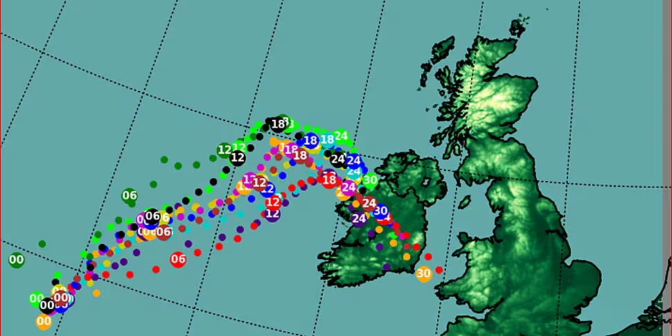
Met Éireann said the Storm Lorenzo has “moved north-north-eastward parallel to the west coast of Ireland this afternoon as forecasted” and is likely to turn east in the coming hours “whilst weakening.”
It said latest forecast indicate the storm’s eastward progression has now slowed.
“This means that we could see a more prolonged period of heavy rain in north-western parts of the country tonight and early tomorrow,” it said.
"Threat to life"
The orange wind warning for Galway, Mayo, Clare, Kerry and Limerick has been extended into 6.00am on Friday.
Minister for Housing Eoghan Murphy says people in these counties should take particular care.
"Kerry, Limerick, Galway, Mayo and Clare are still under orange, and that warning has been extended in time.
"A status orange is a serious condition: it may pose a threat to life and safety.
"All of the country will experience this storm, but the effects will be different in different parts of the country.
"Our primary concern since Tuesday, and it remains our primary concern, is the west and north-west coasts".
See a detailed weather forecast here
Superintendent Tom Murphy from @GardaTraffic has warned the public to stay away from coastal areas and coastal roads. He has advised that drivers should remain vigilant particularly overnight. #stormlorenzo pic.twitter.com/JO4w1BGTh3
— MerrionStreet.ie (@merrionstreet) October 3, 2019
A Status Yellow wind warning was in place for the whole country since 9am this morning; however, it has now been lifted.
Yellow wind warnings will remain for Leitrim and Sligo until 6am tomorrow.
Hurricanes rarely travel as far east or north in the Atlantic as #Lorenzo. Now weakened to an extratropical cyclone, it is bringing heavy rains to Ireland. Our @NASAEarth satellite imaged the storm Oct. 2 (image 1) and Oct. 3 (image 2). Continued tracking: https://t.co/lCMTxFoAUJ pic.twitter.com/SvWxbdlPrK
— NASA (@NASA) October 3, 2019
Storm Lorenzo
Storm Lorenzo was located around 340 kms west of Belmullet, Co Mayo at midday on Thursday.
As the centre of the storm passed over, storm force west to southwest gusts were recorded on the southern side of the low pressure centre.
Met Éireann says the storm will track north-eastwards to the west of Ireland.
South-easterly winds will be strong and gusty over much of the country, with a countrywide yellow wind warning in operation until 6.00pm.
Stay Back, Stay High & Stay Dry!
We strongly advise the public to stay away from exposed beaches, cliffs, harbours and promenades along the coast during storm conditions.
If you see someone in difficulty in the sea or on the shore dial 112 and ask for Coast Guard #Lorenzo pic.twitter.com/a8NVb3ZIY6
— Irish Coast Guard (@IrishCoastGuard) October 3, 2019
The storm depression is forecasted to then turn east south-eastwards this evening towards the west coast of Co Mayo.
This turn is due to upper air steering flows high up in the atmosphere.
By this time, the depression will be starting to fill - this means the storm force winds on the southern side of the low will begin to slowly subside.
At 6.00pm, the orange level wind warning for western coastal counties of Galway, Mayo, Clare, Kerry and Limerick will come into operation - and the yellow wind warning will become confined to Cork, Waterford, Tipperary and Wexford.
Lorenzo is expected to make landfall between Erris Head and Killala Bay in Co Mayo around midnight or soon after.
Strong winds and large waves will affect western and southern coasts this evening and tonight with the potential for coastal flooding and damage.
#StormLorenzo may result in some customers losing supply. Please take note of your MPRN number - for more information on MPRN and how to find it click here https://t.co/8BPPMmizYI pic.twitter.com/uIsx87OVwy
— ESB Networks (@ESBNetworks) October 3, 2019
Winds in the centre and to the north will be generally light to moderate variable.
There will, however, be pulses of heavier rain in the centre and to the north - with a yellow rainfall warning in operation.
Lorenzo is the eastern most and northern most category five hurricane ever recorded in the Atlantic Ocean.
But it transitioned from a hurricane to an extra-tropical storm approximately 1,000km southwest of Ireland.
By comparison, Storm Ophelia in October 2017 retained its hurricane status until it was within 500km of Ireland.


